Maps and Plans: Difference between revisions
Paul Steane (talk | contribs) m (→Lithuania: Vaidotai.gif replaced by Vaidotai.png) |
Paul Steane (talk | contribs) (→Germany: Piesberg-Osnabrück added) |
||
| (38 intermediate revisions by 3 users not shown) | |||
| Line 6: | Line 6: | ||
Please remember that the maps were current at the dates when they were created but may have been overtaken by subsequent events. | Please remember that the maps were current at the dates when they were created but may have been overtaken by subsequent events. | ||
==Australia== | |||
<gallery> | |||
Image:Brisbane1.pdf|Brisbane I | |||
Image:Brisbane2.pdf|Brisbane II | |||
</gallery> | |||
==Austria== | ==Austria== | ||
| Line 11: | Line 18: | ||
<gallery> | <gallery> | ||
Image:Linz.png|Linz | Image:Linz.png|Linz | ||
Image:Wien1.png|Wien (west) | Image:Wien1.png|Wien (west) as at May 2001 | ||
Image:Wien2.png|Wien (east) | Image:Wien2.png|Wien (east) as at May 2001 | ||
Image:Wien_Meidling-Wien_Hbf.png|Wien-Meidling / Wien Hbf as at October 2017 | |||
Image:Villach.png|Villach | Image:Villach.png|Villach | ||
</gallery> | </gallery> | ||
| Line 21: | Line 29: | ||
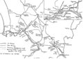
Image:Bruxelles.png|'''Brussel/Bruxelles''' including Schaarbeek/Schaerbeek & Etterbeek/Delta areas | Image:Bruxelles.png|'''Brussel/Bruxelles''' including Schaarbeek/Schaerbeek & Etterbeek/Delta areas | ||
Image:Montzen.png|Tongeren - Visé Haut - Montzen - Aachen (Germany) | Image:Montzen.png|Tongeren - Visé Haut - Montzen - Aachen (Germany) | ||
</gallery> | |||
==Bosnia-Hercegovina== | |||
<gallery> | |||
Image:Sarajevo.png|Sarajevo | |||
Image:Republika Srpska.png|Republika Srpska | |||
Image:Bosnia 1.png|Bosnia 1 | |||
Image:Bosnia 2.png|Bosnia 2 | |||
</gallery> | |||
==Bulgaria== | |||
<gallery> | |||
Image:Sofia East.png|Sofia East | |||
Image:Sofia West.png|Sofia West | |||
</gallery> | </gallery> | ||
| Line 33: | Line 57: | ||
<gallery> | <gallery> | ||
Image:Brno.png|Brno as at July 2017 | |||
Image:Brno Zidenice.jpg|Brno-Židenice – odbočka Slatinská | |||
Image:Havlickuv Brod.png|Havlickuv Brod | |||
Image:Liberec.jpg|Liberec | |||
Image:Most-Kopisty modified.jpg|Most-Kopisty showing unusual route | |||
Image:Praha1.png|Praha 1 | Image:Praha1.png|Praha 1 | ||
Image:Praha1A.png|Praha 1 showing revised layout to the east of Praha hl.n. and Masarykovo n. | Image:Praha1A.png|Praha 1 showing revised layout to the east of Praha hl.n. and Masarykovo n. | ||
Image:Praha2.png|Praha 2 | Image:Praha2.png|Praha 2 | ||
</gallery> | |||
==Denmark== | |||
<gallery> | |||
Image:Nordhavn.png|Nordhavn | |||
</gallery> | </gallery> | ||
| Line 46: | Line 80: | ||
Image:Berlin1.png|Berlin 1 (Jungfernheide - Lehrter Bahnhof) | Image:Berlin1.png|Berlin 1 (Jungfernheide - Lehrter Bahnhof) | ||
Image:Berlin2.png|Berlin 2 (Treptow - Neukölln - Schönefeld) | Image:Berlin2.png|Berlin 2 (Treptow - Neukölln - Schönefeld) | ||
Image:Berlin3.png|Berlin 3 (Hauptbahnhof - | Image:Berlin3.png|Berlin 3 (Hauptbahnhof - Südkreuz - Ludwigsfeld) | ||
Image:Berlin4.png|Berlin 4 (Charlottenburg - | Image:Berlin4.png|Berlin 4 (Charlottenburg - Westkreuz - Grunewald) | ||
Image:Spandau.png|Spandau area of Berlin | Image:Spandau.png|Spandau area of Berlin | ||
Image:Bitterfeld.png|Bitterfeld | Image:Bitterfeld.png|Bitterfeld | ||
| Line 59: | Line 93: | ||
Image:Erfurt.png|Erfurt | Image:Erfurt.png|Erfurt | ||
Image:Gladbeck.png|Gladbeck - Ruhrkohle AG system | Image:Gladbeck.png|Gladbeck - Ruhrkohle AG system | ||
Image:Gröbers.png|Junction at Gröbers on Erfurt to Leipzig NBS | |||
Image:Hannover1.png|Hannover 1 (west) | Image:Hannover1.png|Hannover 1 (west) | ||
Image:Hannover2.png|Hannover 2 (east and south) | Image:Hannover2.png|Hannover 2 (east and south) | ||
| Line 78: | Line 113: | ||
Image:Mussum.png|Mussum | Image:Mussum.png|Mussum | ||
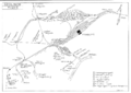
Image:Muenchen.png|München, showing connections to the Nordring freight line | Image:Muenchen.png|München, showing connections to the Nordring freight line | ||
Image:Osnabrück.png|Osnabrück | |||
Image:Piesberg-Osnabrück.png|Piesberg-Osnabrück | |||
Image:Regensburg.png|Regensburg | Image:Regensburg.png|Regensburg | ||
Image:Rheinhausen.png|Rheinhausen Ost: Logport | Image:Rheinhausen.png|Rheinhausen Ost: Logport | ||
| Line 88: | Line 125: | ||
Image:Unna_k.png|Unna Königsborn | Image:Unna_k.png|Unna Königsborn | ||
Image:Wanne.png|Wanne Eickel | Image:Wanne.png|Wanne Eickel | ||
Image:Wilhelmshaven.png|Wilhelmshaven | |||
Image:Wismut.png|Wismutbahn | Image:Wismut.png|Wismutbahn | ||
Image:Zschornewitz.png|Zschornewitz-Vockerode, the brown-coal mining area near Dessau | Image:Zschornewitz.png|Zschornewitz-Vockerode, the brown-coal mining area near Dessau | ||
| Line 98: | Line 136: | ||
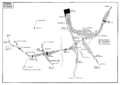
Image:Budapest_2.png|Budapest part 2 | Image:Budapest_2.png|Budapest part 2 | ||
Image:Budapest_3.png|Budapest part 3 | Image:Budapest_3.png|Budapest part 3 | ||
Image:Eger.png| | Image:Eger2.jpg|Eger | ||
Image:Szolnok.png|Szolnok | |||
</gallery> | </gallery> | ||
| Line 104: | Line 143: | ||
<gallery> | <gallery> | ||
Image: | Image:Milano1.pdf|Milano1 | ||
Image:Milano2.pdf|Milano2 | |||
Image:Napoli.png|Napoli | Image:Napoli.png|Napoli | ||
Image:Napoli_FS_diagram_with_new_HSL_triangle.png|Napoli with new HSL triangle | |||
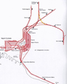
Image:Roma.png|Roma | Image:Roma.png|Roma | ||
Image:Vatican.png|Vatican City | Image:Vatican.png|Vatican City | ||
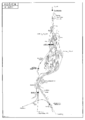
| Line 113: | Line 154: | ||
<gallery> | <gallery> | ||
Image:Vaidotai.png|Vaidotai | Image:Vaidotai.png|Vaidotai | ||
</gallery> | |||
==Norway== | |||
<gallery> | |||
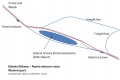
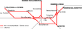
Image:Oslo Lufthavn.png|Routes to Oslo airport | |||
Image:NSB_Tonsberg_Realignment.pdf|Tonsberg | |||
</gallery> | </gallery> | ||
| Line 118: | Line 166: | ||
<gallery> | <gallery> | ||
Image:Czerwiensk area.png|Czerwiensk | |||
Image:Gdynia 1.jpg|Gdynia | |||
Image:Ilawa.jpg|Ilawa | |||
Image:Kepno.jpg|Kepno | |||
Image:Koluszki.jpg|Koluszki | |||
Image:Lazy.jpg|Lazy | |||
Image:Piła - Piła Towarowa - podg Piła Północ.jpg|Piła | |||
Image:Poznan.jpg|Poznan | |||
Image:Rumia 1.jpg|Rumia | |||
Image:Rzepin station area.png|Rzepin | |||
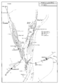
Image:Szczecin.png|Szczecin | Image:Szczecin.png|Szczecin | ||
Image:Szczecin Podjucy - Szczecin Zdroje.jpg|Szczecin Podjucy - Szczecin Zdroje | |||
Image:Tczew.jpg|Tczew | |||
Image:Wroclaw1.jpg|Wroclaw1 | |||
Image:Wroclaw2.jpg|Wroclaw2 | |||
</gallery> | |||
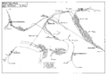
==Romania== | |||
<gallery> | |||
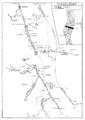
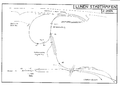
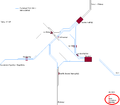
Image:Constanţa.gif|Constanţa | |||
</gallery> | |||
==Serbia== | |||
<gallery> | |||
Image:Beograd_1.pdf|Beograd North as at July 2016 | |||
Image:Beograd_2.pdf|Beograd South as at July 2016 | |||
Image:Cuprija deviation.jpg|Cuprija | |||
</gallery> | </gallery> | ||
| Line 137: | Line 213: | ||
<gallery> | <gallery> | ||
Image:Andalucia.png| | |||
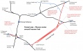
Image: | Image:Valencia1.jpg|PSUL route of València San Isidre – València Fuente San Luis (Bif. Clasificación Valencia F.S.L.) | ||
Image: | Image:Sevilla1.jpg|PSUL route for [Córdoba –] La Rinconada (Majarabique) – Majarabique cambiador de ancho – Carrión de los Céspedes (Bif. San Jerónimo) | ||
Image:Sevilla2.jpg|PSUL route for [Córdoba –] La Rinconada (Majarabique) – Majarabique cambiador de ancho – Sevilla Santa Justa (Bif. Los Naranjos) | |||
Image:Antequera S A - Bobadilla.png|The '''Antequera Santa Ana - Bobadilla''' area of Andalucía, showing new connections and those under construction | |||
Image:Leon.png|Leon area as at December 2012 | |||
Image:Galicia & Leon LAV Map 1.jpg|Diagrammatic map of LAV and associated lines in the area of Galicia & Leon as at January 2016 | |||
Image:Galicia & Leon LAV Map 2.jpg|Diagrammatic map of LAV and associated lines in the area of Galicia & Leon as at January 2016 | |||
Image:Espeluy.png|Historical map of the '''Espeluy - Linares''' area of Andalucia in 2000 | |||
Image:Andalucia.png|Historical map of the '''Sevilla - Granada''' line through Andalucia, showing 1990s cut-offs or ''Variantes'' | |||
Image:Sevilla.png|Historical map of Sevilla 2001 | |||
</gallery> | |||
==Sweden== | |||
<gallery> | |||
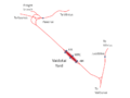
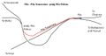
Image:Ange3.jpg|Ånge – Bräcke (Moradal) (via Ångebyn) | |||
Image:Ange4.jpg|Bollnäs (Ovansjö) – Bräcke (Moradal) (via Ångebyn) | |||
Image:Malmo3.jpg|Malmö | |||
</gallery> | </gallery> | ||
| Line 146: | Line 238: | ||
<gallery> | <gallery> | ||
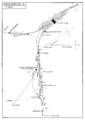
Image:Tunis.png|Tunis | Image:Tunis.png|Tunis | ||
</gallery> | |||
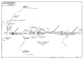
==Turkey== | |||
<gallery> | |||
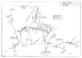
Image:Kutahya and Alayunt area 3.jpg|Kutahya and Alayunt area | |||
Image:Tatvan.jpg|Tatvan Gar – Tatvan İskele | |||
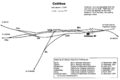
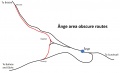
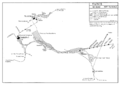
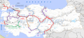
Image:Turkey_Signalling_Map.png|Type of signalling on each line | |||
</gallery> | </gallery> | ||
Revision as of 13:19, 8 October 2019
Railway Maps and Plans - Europe and beyond
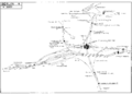
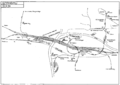
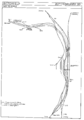
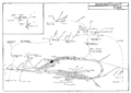
Many of the railway layout maps and plans on this page were drawn by Rodger Wilkinson of Chester-le-Street and Gregory Beecroft of Welwyn Garden City. These maps were formerly hosted on the 'Rinbad' website, but have been moved with permission.
You may access the maps and print them for personal use, but must not use them for any purpose involving resale. You may have more control of how your printer fits a map on to a paper page if you Save As File and print from another program such as Microsoft Photo Editor rather than printing direct from your browser.
Please remember that the maps were current at the dates when they were created but may have been overtaken by subsequent events.
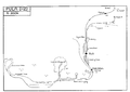
Australia
-
Brisbane I
-
Brisbane II
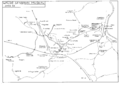
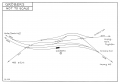
Austria
-
Linz
-
Wien (west) as at May 2001
-
Wien (east) as at May 2001
-
Wien-Meidling / Wien Hbf as at October 2017
-
Villach


Belgium
-
Brussel/Bruxelles including Schaarbeek/Schaerbeek & Etterbeek/Delta areas
-
Tongeren - Visé Haut - Montzen - Aachen (Germany)


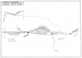
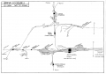
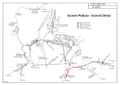
Bosnia-Hercegovina
-
Sarajevo
-
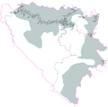
Republika Srpska
-
Bosnia 1
-
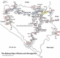
Bosnia 2


Bulgaria
-
Sofia East
-
Sofia West


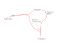
Croatia
-
Pula
-
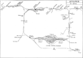
Zagreb


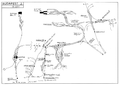
Czech Republic
-
Brno as at July 2017
-
Brno-Židenice – odbočka Slatinská
-
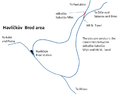
Havlickuv Brod
-
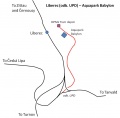
Liberec
-
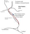
Most-Kopisty showing unusual route
-
Praha 1
-
Praha 1 showing revised layout to the east of Praha hl.n. and Masarykovo n.
-
Praha 2


Denmark
-
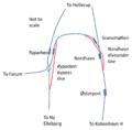
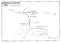
Nordhavn

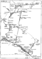
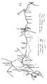
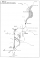
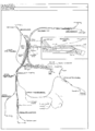
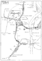
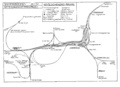
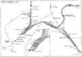
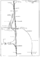
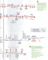
Germany
-

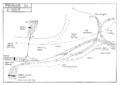
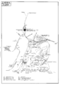
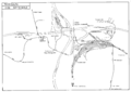
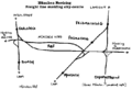
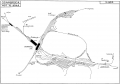
Aachen
-
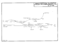
Amstetten (Württ.)
-
Bad Muskau area near Polish border, including Waldeisenbahn and local mineral-line connections
-
Berlin 1 (Jungfernheide - Lehrter Bahnhof)
-
Berlin 2 (Treptow - Neukölln - Schönefeld)
-
Berlin 3 (Hauptbahnhof - Südkreuz - Ludwigsfeld)
-
Berlin 4 (Charlottenburg - Westkreuz - Grunewald)
-
Spandau area of Berlin
-
Bitterfeld
-
Braunschweig
-
Bremen 1 (west)
-
Bremen 2 (east)
-
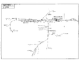
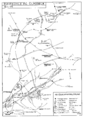
Cottbus, showing arrangement of platforms and accessibility from converging routes
-
Düsseldorf
-
Emden
-
Emmerich Hafen
-
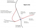
Erfurt
-
Gladbeck - Ruhrkohle AG system
-
Junction at Gröbers on Erfurt to Leipzig NBS
-
Hannover 1 (west)
-
Hannover 2 (east and south)
-
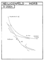
Heiligenfeld, Horb
-
Ingolstadt
-
Kassel
-
Kiel
-
Köln 1 (west - Hauptbahnhof and Eifeltor)
-
Köln 2 (east - Deutz and Gremberg)
-
Laabertalbahn (Eggmühl - Langquaid)
-
Leipzig
-
Lübeck
-
Lünen Süd: Stadthafen
-
Magdeburg 1
-
Magdeburg 2
-
Meitingen: SGL Carbon, Krauchenwies: Tegomettall, Rottenacker: Fa.Bohnacker, Baienfurt: Stora Enso
-
Minden
-
Bahnen der Stadt Monheim
-
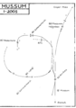
Mussum
-
München, showing connections to the Nordring freight line
-
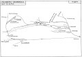
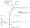
Osnabrück
-
Piesberg-Osnabrück
-
Regensburg
-
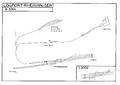
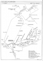
Rheinhausen Ost: Logport
-
Saarbrücken
-
Spandau area of Berlin
-
Stuttgart 1 (Hauptbahnhof - Untertürkheim)
-
Stuttgart 2 (Zuffenhausen - Ludwigsburg)
-
Ulm
-
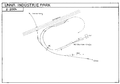
Unna: Industriepark
-
Unna Königsborn
-
Wanne Eickel
-
Wilhelmshaven
-
Wismutbahn
-
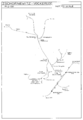
Zschornewitz-Vockerode, the brown-coal mining area near Dessau


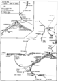
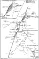
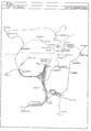
Hungary
-
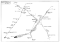
Budapest part 1
-
Budapest part 2
-
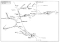
Budapest part 3
-
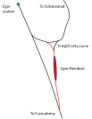
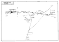
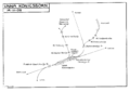
Eger
-
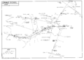
Szolnok


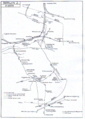
Italy
-

Milano1
-
Milano2
-
Napoli
-
Napoli with new HSL triangle
-
Roma
-
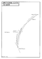
Vatican City


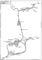
Lithuania
-
Vaidotai

Norway
-
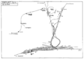
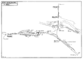
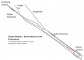
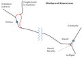
Routes to Oslo airport
-
Tonsberg

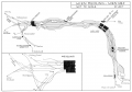
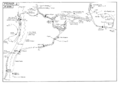
Poland
-

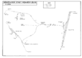
Czerwiensk
-
Gdynia
-
Ilawa
-
Kepno
-
Koluszki
-
Lazy
-
Piła
-
Poznan
-
Rumia
-

Rzepin
-
Szczecin
-
Szczecin Podjucy - Szczecin Zdroje
-
Tczew
-
Wroclaw1
-
Wroclaw2


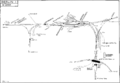
Romania
-
Constanţa

Serbia
-
Beograd North as at July 2016
-
Beograd South as at July 2016
-
Cuprija
Slovakia
-
Bratislava
-
Košice


Slovenia
-
Ljubljana

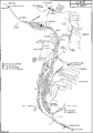
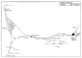
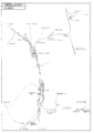
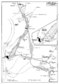
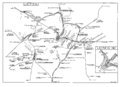
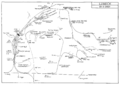
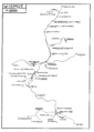
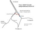
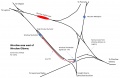
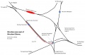
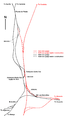
Spain
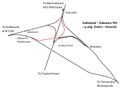
-
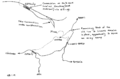
PSUL route of València San Isidre – València Fuente San Luis (Bif. Clasificación Valencia F.S.L.)
-
![PSUL route for [Córdoba –] La Rinconada (Majarabique) – Majarabique cambiador de ancho – Carrión de los Céspedes (Bif. San Jerónimo)](/w/images/thumb/0/0a/Sevilla1.jpg/120px-Sevilla1.jpg)
PSUL route for [Córdoba –] La Rinconada (Majarabique) – Majarabique cambiador de ancho – Carrión de los Céspedes (Bif. San Jerónimo)
-
![PSUL route for [Córdoba –] La Rinconada (Majarabique) – Majarabique cambiador de ancho – Sevilla Santa Justa (Bif. Los Naranjos)](/w/images/thumb/8/80/Sevilla2.jpg/120px-Sevilla2.jpg)
PSUL route for [Córdoba –] La Rinconada (Majarabique) – Majarabique cambiador de ancho – Sevilla Santa Justa (Bif. Los Naranjos)
-
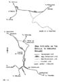
The Antequera Santa Ana - Bobadilla area of Andalucía, showing new connections and those under construction
-
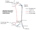
Leon area as at December 2012
-
Diagrammatic map of LAV and associated lines in the area of Galicia & Leon as at January 2016
-
Diagrammatic map of LAV and associated lines in the area of Galicia & Leon as at January 2016
-
Historical map of the Espeluy - Linares area of Andalucia in 2000
-
Historical map of the Sevilla - Granada line through Andalucia, showing 1990s cut-offs or Variantes
-
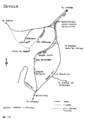
Historical map of Sevilla 2001
![PSUL route for [Córdoba –] La Rinconada (Majarabique) – Majarabique cambiador de ancho – Carrión de los Céspedes (Bif. San Jerónimo)](/wiki/File:Sevilla1.jpg)
![PSUL route for [Córdoba –] La Rinconada (Majarabique) – Majarabique cambiador de ancho – Sevilla Santa Justa (Bif. Los Naranjos)](/wiki/File:Sevilla2.jpg)


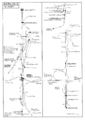
Sweden
-
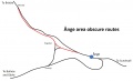
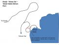
Ånge – Bräcke (Moradal) (via Ångebyn)
-
Bollnäs (Ovansjö) – Bräcke (Moradal) (via Ångebyn)
-
Malmö


Tunisia
-
Tunis

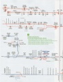
Turkey
-
Kutahya and Alayunt area
-
Tatvan Gar – Tatvan İskele
-
Type of signalling on each line


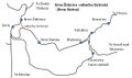
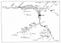
Ukraine
-
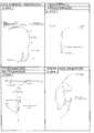
Kharkiv
-
Korosten’
