Maps and Plans: Difference between revisions
Paul Steane (talk | contribs) (Italy - Poland - Slovakia - Slovenia - Spain - Tunisia maps moved into Wiki) |
Paul Steane (talk | contribs) m (→Belgium) |
||
| Line 21: | Line 21: | ||
<gallery> | <gallery> | ||
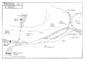
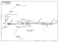
Image:Bruxelles.png|Brussel/Bruxelles | Image:Bruxelles.png|'''Brussel/Bruxelles''' including Schaarbeek/Schaerbeek & Etterbeek/Delta areas | ||
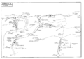
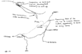
Image:Montzen.png|Tongeren - Visé Haut - Montzen - Aachen (Germany) | Image:Montzen.png|Tongeren - Visé Haut - Montzen - Aachen (Germany) | ||
</gallery> | </gallery> | ||
Revision as of 17:10, 12 February 2012
Railway Maps and Plans - Europe and beyond
Rodger Wilkinson of Chester-le-Street and Gregory Beecroft of Welwyn Garden City have drawn a number of maps and plans some of railway layouts.
These maps were formerly hosted on the 'Rinbad' website, but have been moved with permission. All files are in PNG format.
You may access the maps and print them for personal use, but must not use them for any purpose involving resale. You may have more control of how your printer fits a map on to a paper page if you Save As File and print from another program such as Microsoft Photo Editor rather than printing direct from your browser.
Please remember that the maps were current at the dates when they were created but may have been overtaken by subsequent events.
Austria
-
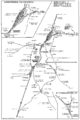
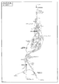
Linz
-
Wien (west)
-
Wien (east)
-
Villach


Belgium
-
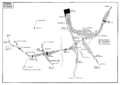
Brussel/Bruxelles including Schaarbeek/Schaerbeek & Etterbeek/Delta areas
-
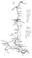
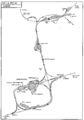
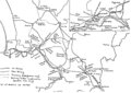
Tongeren - Visé Haut - Montzen - Aachen (Germany)


Croatia
-
Pula
-
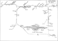
Zagreb


Czech Republic
-
Praha 1
-
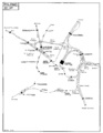
Praha 1 showing revised layout to the east of Praha hl.n. and Masarykovo n.
-
Praha 2


Italy
-
Milano
-
Napoli
-
Roma
-
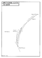
Vatican City


Poland
-
Szczecin

Slovakia
-
Košice

Slovenia
-
Ljubljana

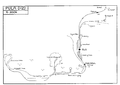
Spain
-
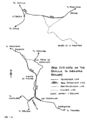
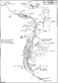
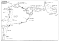
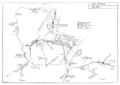
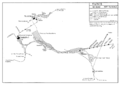
The Sevilla - Granada line through Andalucia, showing 1990s cut-offs or Variantes
-
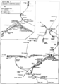
The Espeluy - Linares area of Andalucia
-
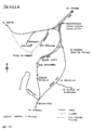
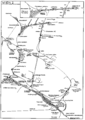
Sevilla


Tunisia
-
Tunis
